Wednesday 3 October - it's been a while....
I spent yesterday in the hills of Sutherland, my first fieldwork day in the wilds for several weeks.
Fortunately the weather was reasonably benign, with just a few passing showers.
It helps if it is not too wet because I find that writing on a printed aerial image of the site is still the best way of producing the most accurate results. I am not a technophobe by any means and I still make use of my phone for recording GPS data and establishing my precise location. However, patterns of vegetation cover on the aerial photo are usually sufficient to allow me to orientate myself and - together with a peat probe, spade and visual clues of the underlying ground conditions - produce a rough design for a new woodland that I then digitise and tweak when back in the office.
The system fails if it is really raining hard, even when using waterproof paper and adapting my work method to make more use of the phone, which is less affected by the weather unless it is really grim.
I had quite a lot of ground to cover and the ever changing landform and plant communities prevented me from making too many assumptions about the suitability of any particular area for supporting tree establishment (peat depth being the most significant constraint in this respect).
Because I had so little time, I did not stop to take too many pictures and those that I did take are not that great.
Even so, I present a few of them here as they provide a good indication of the type of ground that I was surveying and the reasons for doing it.
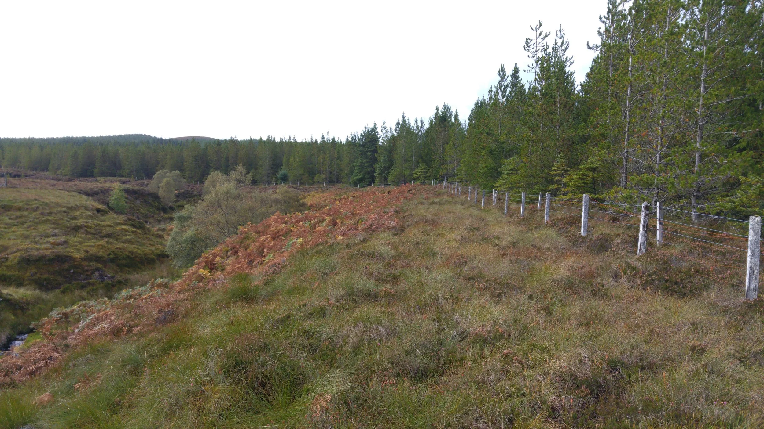
This picture shows some of the lower ground that I was surveying. It is interesting because the underlying geology and the soil conditions are the same - broadly speaking - in all areas that appear in the photo, yet the vegetation cover is markedly different. To the left, there is largely un-managed ground, perhaps subject to some light grazing by sheep. The dominant vegetation cover here is heather (Calluna vulgaris) and there are also some stands of scattered native woodland. To the right of the stock fence the ground is unimproved, improved and semi-improved rough grassland. These areas are permanently grazed by sheep. On that side of the fence, the brown grass in the foreground is Deer grass (Trichophorum germanicum) and it is the dominant vegetation cover where the ground has not been improved. The dark green areas on the slopes above it were improved by adding lime. This was done in the 1970s. The improved areas were then reseeded with a commercial grass mix at the same time. Although it is difficult to see this clearly in the image, there is a small area of pale green ground to the right of the fence and immediately above the amber hues of the Deer grass. This area was limed but not reseeded, so the sward is unimproved and consists mainly of the rough grasses that were present at the time.

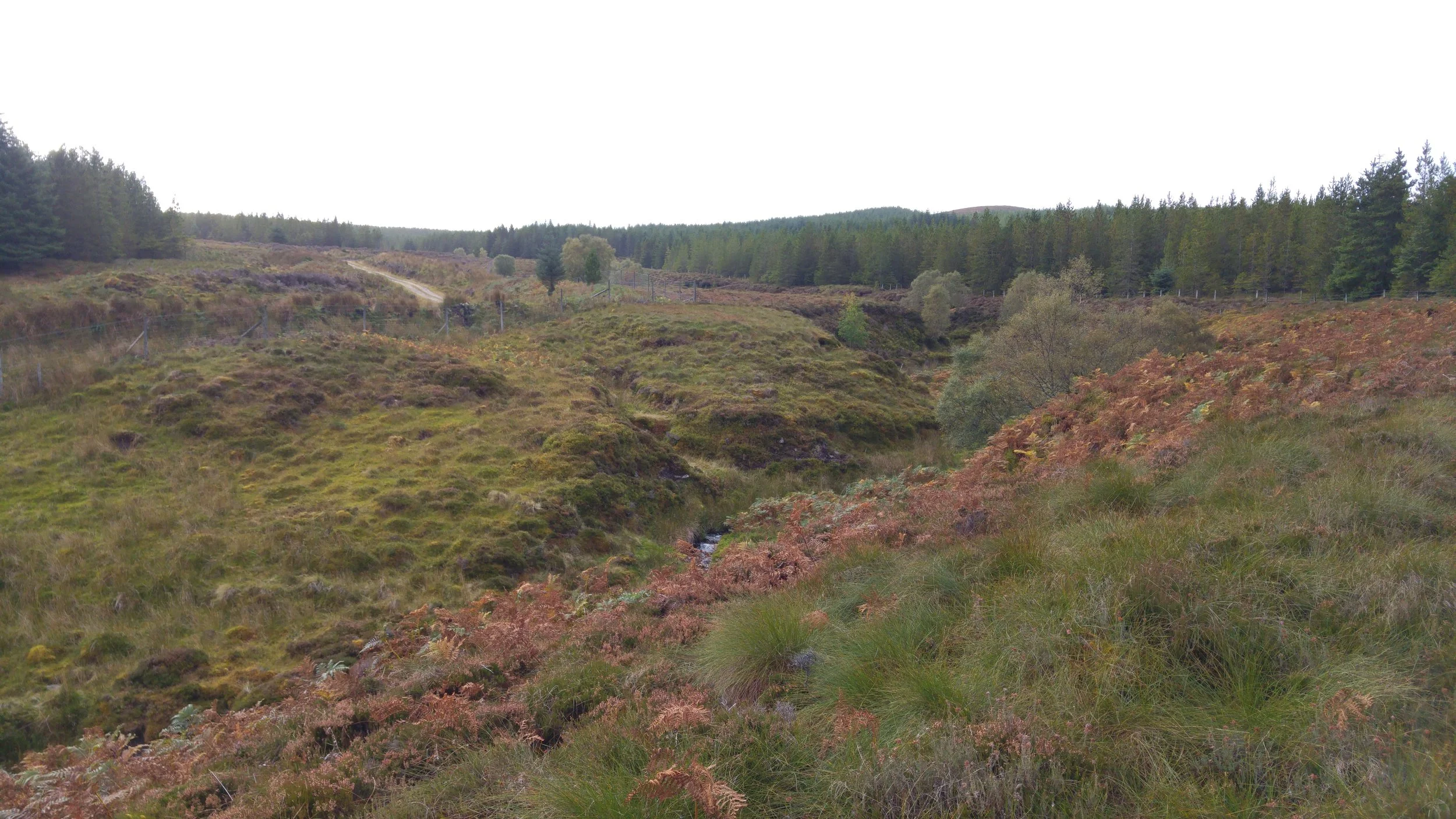
Further up the hill, I came to the main project area. Here, we have open ground on both sides of a minor watercourse (not easy to see in the picture) which is located between several blocks of non native conifers that were planted for timber production. The species in these plantations are typical of this upland environment: Scots pine, Lodgepole pine, Sitka spruce and larch. My purpose of being here was to consider whether it was worthwhile excluding deer from these areas of open ground and then planting native trees to restore the natural tree cover. Unfortunately, it did not take long to realise that the peat was too deep to support grant funded tree planting in most places, even though the nutrient status was sufficiently good for heather to grow quite well in some areas.
Here, the watercourse and its gulley can be seen on the left hand side of the picture. On the right, the 1970s plantations can be seen close to the riparian zone. Those conifers were planted on peat that is probably approaching two metres deep. As a result, the growth rate and quality is not very good even after almost forty years. An extensive stand of bracken (Pteridium aquilinum) can be seen in the middle distance. As foresters, we often think that bracken indicates good ground that can support tree growth. That is true to a degree, but bracken can also grow on very poor ground so one has to also consider its form when visually assessing the ground of its suitability for tree planting (e.g. stand spread and height). In this case, the bracken was of reasonable form but the peat depth was too deep for tree planting without substantial - and undesirable - management inputs. I suspect that the bracken was growing well because of nutrients being washed into the area in which it was growing, rather than an indication of underlying soil fertility. In other words, it was growing in a 'flushed peat'. Of course, a considerable disadvantage of the presence of bracken on a site is that it will seriously impede tree establishment. Its presence therefore requires control both before and during the tree establishment phase and this adds to the cost of implementing the project. Considering this cost and the high price of manual labour, chemical controls are the best solution in many situations and at this moment in time.
Upon first glance, this looks like an ideal place to plant some trees: small knolls of well drained ground within the riparian zone with an underlying mineral soil and reasonable fertility. Actually, upon looking more closely, my peat probe indicated that the peat was too deep for any tree planting work to be eligible for grant support and that most of the project costs would probably have to be met by the landowner.

Although the peat was too deep to qualify for grant supported tree planting, some areas contained an encouraging amount of self seeded Downy birch (Betula pubescens). The few remaining mature birch trees around the riparian zone were probably the source of the seed. A new deer fence had been built on one side of the watercourse some time in the last five years and I thought that these young birch had been able to grow to their current height because the fence had reduced the effects of browsing by deer. If more deer fences were built around the project area, the deer could be completely excluded and the self seeded trees would stand a better chance of becoming fully established and more self seeding would occur. Other vegetation such as blaeberry (Vaccinium myrtillus) would recover as well. In this case, the next step would be to assess the cost of doing this work and establishing how much of it could be recovered with a grant application. There is no guarantee of being awarded a grant so the project must be considered with caution and developed with a close eye on expenditure. Such are the cruel realities of ecological restoration in the uplands!